Looking out on Samish Bay from Larrabee State Park
I took a three-day tour around the Olympic Peninsula and north Puget Sound, driving from trail to trail and camping out of the back of my Jeep. I'm short enough that I can put down the rear seats and stretch out in a sleeping bag, and it's nice not having to put up/take down a tent every day.
Day 1
Another view of the afternoon mist.
Day 2
View of the bay from halfway up Oyster Dome.
Run: Oyster Dome Loop, 8 miles and 3000ft of gain. I was treated to a great view of Samish Bay at the top and watched clouds roll west off Chuckanut into the bay. This trail was really gnarly and gave my ankles a good workout; I'll let the pictures speak for themselves.
Are your ankles and quads ready?
No, no they are not. Going up burns almost as bad as going down.
View from the top of Oyster Dome, about 2100ft.
Drive: From Bellingham to Whidbey Island via Deception Pass.
The bluffs at Ebey; thar be whar we're headed.
Run: Out-and-back at Ebey Landing, heading northward out of the park along the bluffs, then dropping down to the lagoon and the beach to return to the park. 8 miles and maybe 400ft of gain from the initial climb and rolling hills. The trail was overgrown past 2 miles, but the dirt trail is runnable with few rocks and unobstructed views of the Sound. There was some misting rain and a weak westerly wind.
Heading up to the bluffs along the edge of the farms.
On the bluffs looking north to the lagoon that hugs the coastline.
Running the lagoon trail, which snaked all over the place and was overgrown at the south end. Certainly the road less traveled, here.
Drive: From Whidbey Island to Port Angeles via the Keystone Ferry, overnighting at Altair campground in Elwha in the foothills of the Olympics, nestled in the Elwha River Valley.
Bringing it home on the beach.
Day 3
The first of many stream crossings.
Run: Hurricane Hill Trail, from the Elwha Ranger Station to the top of Hurricane Hill and back, 14 miles and 6000ft of gain. The trail is very technical and steep for the first 3 miles, but once it reaches the meadows above 4500ft it's very runnable. There were numerous stream crossings early on, surging from the unusually large snow pack this year.
Starting to hit the high country as the underbrush disappears.
Looking beyond the meadow to the start of the craggy ridge.
I heard snorts and cries just before entering the meadow, so I made a few clicks and vocalizations. Good thing, because as I spilled around the last switchback, I was greeted with a field of about 40 deer, including a few young bucks about 100 feet away who were not going to move off the trail. I slowly bushwhacked around them, cutting a few hundred feet up the hillside. Chompin' on the wildflowers.
The run across the ridge to the final ascent was great, as I was treated to views of the mountains to the east and the ocean to the west. Patchy snow was still on the ground starting at around 5000ft, and on the final ascent I entered a cloud and encountered snow flurries. Visibility deteriorated to only a few hundred feet at the peak, and I could only faintly make out the other mountains.
Ridge-running over to the final ascent.
The view from below the cloud base.
I must not have noticed it on the climb (I was pushing hard to run the whole way), but on the descent I became aware of how cold and windy it was - a brisk, northerly wind of about 10mph, combined with temperatures below freezing, started to nip at my face. I zipped up my jacket tight and entered a now curiously empty meadow...empty, save for a black bear foraging in the bushes farther downslope.
The nice thing about running at this altitude is that you can see the bear rather than stumble into one on a wooded trail.
(S)he glanced at me briefly before returning to the fresh berries, I imagine. I have had numerous encounters with black bears, including one in the Redmond Watershed, and I've found them to be relatively docile, although I suppose that's because it's always been a solitary bear and never a mother and her cubs.
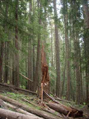
Like Icarus, reaching for the heavens only to be struck down. I wonder how much this tree had seen before its recent demise.
I dropped out of the meadow now devoid of deer and back onto the trail as it curved north around Hurricane Hill toward Elwha. The run finished rather anticlimactically, abruptly dumping me back onto Whiskey Bend Road. Because there was no running water at this campground, I took a quick bath in the Elwha River, with the added benefit of getting an ice-bath, as well. Of course, the time I decide to bathe is the same time that a group of whitewater kayakers drift on by.
Drive: From Elwha to Granny's Cafe for a hearty breakfast. If you are ever in the area, stop by and enjoy the good food and the comfy dining room. It's also the only real restaurant between Port Angeles and Forks.
The original size is huge, but even that doesn't do the view from Cape Flattery justice.
Drive: From Granny's Cafe to Neah Bay and Cape Flattery, the most northwestern point in the continental U.S. There is a short hike down to the rocks overlooking the Pacific, the Strait of Juan de Fuca, and Tatoosh Island. A helpful Makah woman was at the overlook, offering up her binoculars and telescopes to the visitors and pointing out the amazing biological diversity of the Cape - thousands of common murre floating around the island, sea lions sunbathing on isolated rocks, puffins fishing in the surf, and crabs on the far cliffs making a meal of barnacles and muscles affixed to the rocks. The drive to Neah Bay is slow but scenic, and everyone in town was extremely friendly.
Beautiful.
Drive: From Neah Bay to South Beach campground, just south of Kalaloch Lodge. The campground was packed, and I ended up sharing a spot with a Canadian couple. Pro-tip: driftwood releases a lot of aromatic smoke when it's burned. It's easy to start a campfire with it, but it left my clothes and car smelling like a smokehouse. I slept with the rear window open to savor the ocean breeze - by morning it was about 40 degrees and the interior was lightly coated with salt.
Day 4
A calm morning on the lake. Actually, I think this lake is almost always glassy.
Drive: South Beach campground to Lake Quinault. Nothing but trees and logging areas for miles.
Looking off the bridge to one of the many streams that feed into Lake Quinault.
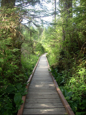
Run: Lake Quinault trails, 10 miles and 500ft of gain. This was a gentle, well-groomed trail with a few short, steep climbs and a few stretches on boardwalks through the bogs. I did pseudo-loop-out-and-back, running along the hillside on the way out to the far campgrounds, and then doubling back and running along the lake. It was a clear, pristine morning with a few thin, wispy layers of fog over the clearings near the lake.
The trail continues up onto the bridge above the falls. There were a lot of these crossings on the hillside trails.
Drive: Lake Quinault to Seattle, stopping in Aberdeen/Hoquiam for coffee and breakfast.
Running the boardwalk through the bog.
3 days, 40 miles, and just under 10000ft of gain. I have never been out to the Olympic Peninsula, and after this trip I'm sure I'll be heading back at some point in the future. I was going to head back to run the Dosewallips-Gray Wolf Pass trail in a couple of weeks, but apparently the road has been washed out and trail conditions are a little hairy. Maybe I'll do Cle Elum Ridge, instead.


No comments:
Post a Comment